
There’s something quietly extraordinary about standing on a cobblestone path in rural Italy, southern France, or even central England and realizing — with a little jolt of disbelief — that the ground beneath your feet was laid down by Roman hands nearly two thousand years ago. Ancient Roman roads weren’t just walkways. They were the nervous system of an empire that stretched from the misty highlands of Scotland to the sun-baked deserts of North Africa. They carried soldiers, merchants, messengers, and ideas. Without them, Rome as we know it simply couldn’t have existed.
If you’ve ever gotten curious about how ancient Roman roads were built, what made them so durable, and why we’re still talking about them today, you’re in good company. These roads have captivated historians, engineers, and everyday travelers for centuries — and for good reason. The story of ancient Roman roads is really the story of ambition, ingenuity, and the very human desire to connect one place to another.
Let’s take a proper walk through that history.
What Were Ancient Roman Roads, Exactly?
Before we get into the engineering and the history, it helps to have a clear picture of what we’re actually talking about when we say “ancient Roman roads.”
Ancient Roman roads — known in Latin as viae (singular: via) — were a vast network of paved and unpaved routes that crisscrossed the Roman Empire at its height. The total length of this network is genuinely staggering. Estimates put it at somewhere between 250,000 and 400,000 kilometers of road, with around 80,000 kilometers of that being stone-paved. To put that in perspective, that’s enough road to circle the Earth roughly six times.
These weren’t dirt tracks or simple footpaths. The major roads — the ones that connected key cities and military outposts — were engineered structures, carefully planned and built to last. And last they did. Many sections of ancient Roman roads are still visible and even walkable today, thousands of years after the empire that built them collapsed.
The Romans had different categories of roads, too. The viae publicae were the main public highways, funded and maintained by the state. The viae vicinales were local roads connecting smaller towns and villages. The viae privatae were essentially private roads on individual estates. For our purposes, we’re mostly talking about those big public highways — the ones that made the empire tick.
Also Read : Best Cities to Visit in Belgium: A Traveler’s Honest Guide to the Best Places
The Origins: How Did Roman Roads Begin?
Rome didn’t start building roads as some grand imperial master plan. Like most great things in history, it happened gradually, out of necessity.
The earliest Roman roads date back to the period of the Roman Republic, well before Rome became the empire we typically picture. The oldest and most famous of them all — the Appian Way, or Via Appia — was begun in 312 BC under the Roman censor Appius Claudius Caecus, whose name it carries. It originally ran from Rome south to Capua, a distance of about 212 kilometers, and was later extended all the way to Brindisi on the southeastern heel of Italy.
The Appian Way was built primarily for military purposes. Rome was expanding its territory, and the army needed a reliable, all-weather route to move troops and supplies quickly. This was really the driving force behind most early Roman road construction — military necessity. A road that lets you move an army faster than your enemy can respond is a tactical advantage that’s hard to overstate.
But military utility quickly led to commercial utility. Merchants figured out fast that a well-paved, properly drained road was a lot better for business than a muddy track that turned to soup every winter. And so ancient Roman roads became arteries of commerce just as much as military highways.
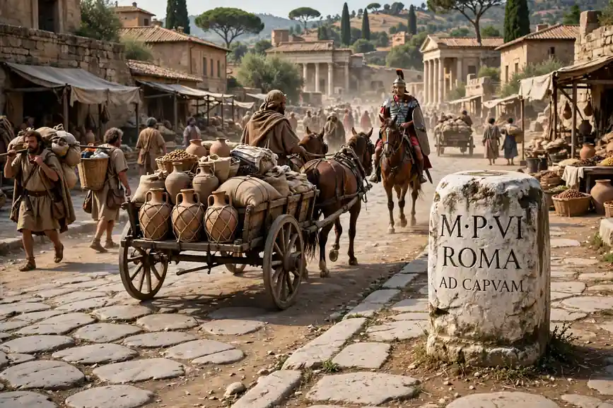
As Rome’s territory expanded — first through Italy, then across the Mediterranean world — the road network expanded with it. Each new province got connected to Rome and to each other. The old saying “all roads lead to Rome” wasn’t just a metaphor. It was a pretty accurate description of how the network was laid out, radiating outward from the golden milestone — the Milliarium Aureum — that the emperor Augustus erected in the Roman Forum.
The Engineering Behind Roman Roads: How Did They Actually Build Them?
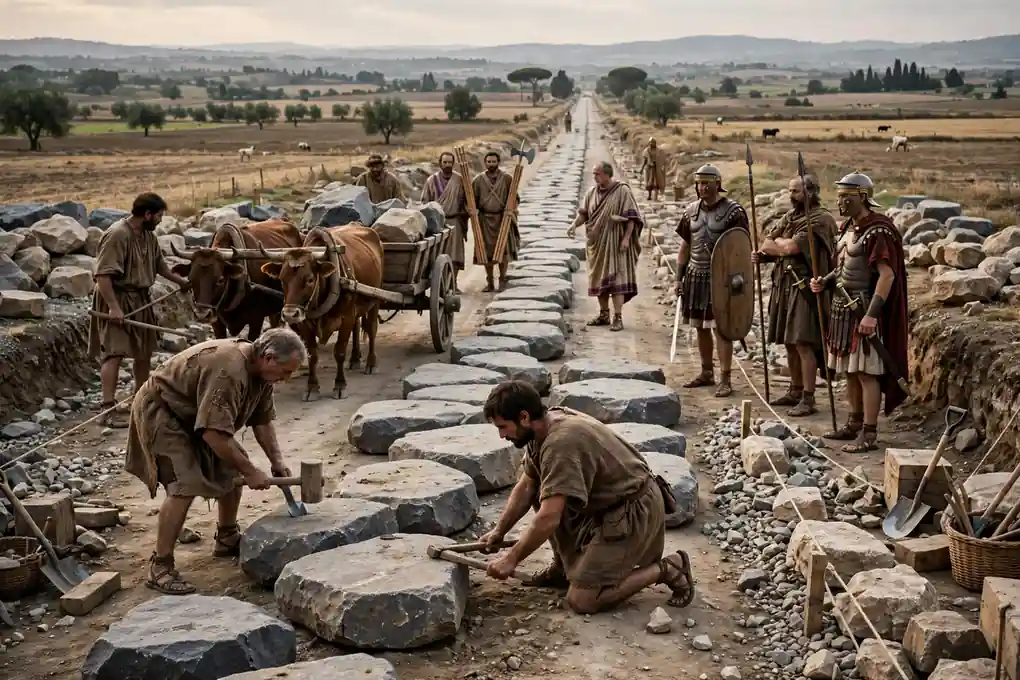
This is the part that genuinely impresses people once they learn the details. Ancient Roman roads weren’t just paved surfaces slapped down on whatever ground happened to be there. They were carefully layered structures, engineered to handle heavy loads, drain water efficiently, and withstand the kind of daily punishment that centuries of use would dish out.
The process started with surveying. Roman engineers — called agrimensores — would scout the route and mark it out using a tool called a groma, which was a kind of cross-shaped sighting device that helped establish straight lines over long distances. The Romans were famously committed to straight roads, and when you look at a map of their road network, that preference is obvious. Where terrain allowed, they went straight. Where it didn’t, they took the most practical route with the fewest unnecessary bends.
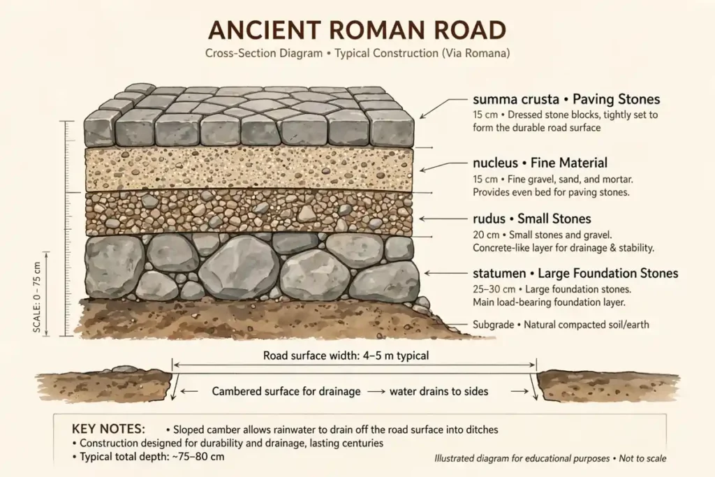
Once the route was established, workers would dig a trench — sometimes several feet deep — along the path. This trench would then be filled in layers:
The first layer was the statumen, large stones or rubble that formed the foundation. This went down deep and provided a solid base.
Above that came the rudus, a layer of smaller stones, gravel, and sometimes concrete made from lime and volcanic ash — a material the Romans were extraordinarily good at making.
Then came the nucleus, a finer layer of gravel and concrete that provided a smooth, stable surface for whatever went on top.
Finally, on major roads, there was the summa crusta — the top layer of large, flat stones, often basalt or limestone, fitted tightly together. These were the distinctive large paving stones you see in photographs of Roman roads.
The whole structure was typically crowned — slightly higher in the middle than at the edges — so that rainwater would run off to the sides rather than pooling on the surface. Drainage channels or ditches were often dug alongside the road for the same reason. This attention to water management is a big part of why so many ancient Roman roads lasted as long as they did.
Roads were typically about 4 to 6 meters wide on major routes, wide enough for two carts to pass each other. Raised stone curbs marked the edges. Milestones — cylindrical stone columns — were placed at regular intervals, noting the distance to the nearest major city.
Major Ancient Roman Roads and Their Routes
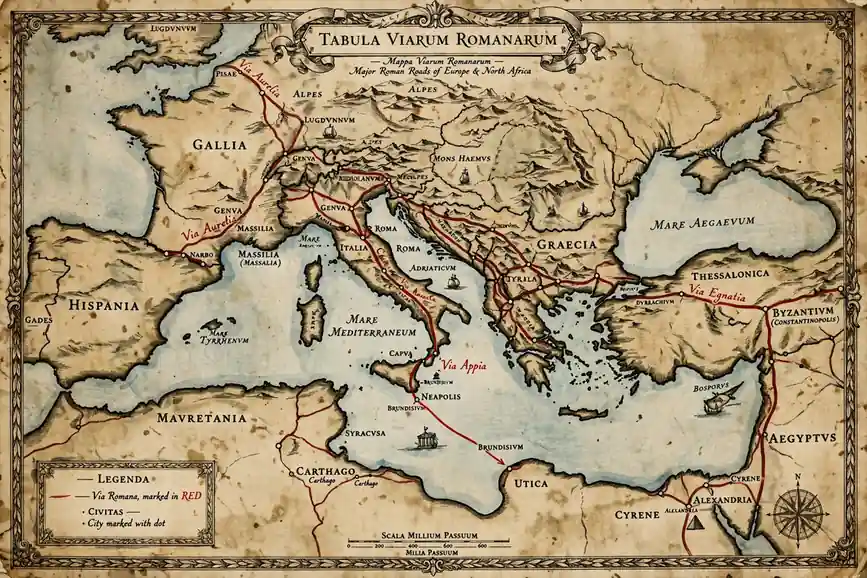
The Roman road network included hundreds of named roads, each with its own history and character. Some of the most significant ones are worth knowing by name.
The Via Appia — the Appian Way — we’ve already mentioned. It’s the queen of Roman roads, the oldest and perhaps most historically significant. Walk sections of it today in the Campagna Romana south of Rome and it feels almost like time travel.
The Via Aurelia ran northwest from Rome along the Tyrrhenian coast all the way up to Genoa and eventually into what is now southern France. It was the main artery connecting Rome to its territories in Gaul and Hispania.
The Via Flaminia headed northeast from Rome, crossing the Apennine mountains and connecting the capital to the Adriatic coast. It was essential for movement into the northern part of Italy.
The Via Egnatia is one of the most remarkable of all ancient Roman roads, stretching from the Adriatic coast at Dyrrachium (modern Durrës in Albania) across the Balkans to Byzantium (modern Istanbul). It was the great road of the eastern empire, used by emperors, armies, merchants, and apostles — the Apostle Paul almost certainly traveled sections of it on his missionary journeys.
In Britain, the Romans built Watling Street, Ermine Street, and the Fosse Way, among others. Watling Street ran from the Channel ports in the southeast up to the northwest of England; much of it still exists as road today, and in some places it forms the boundary between English counties.
Read Must : Best Places to Snorkel in Hawaii: 12 Spots Worth Getting Wet For
Stane Street connected London to Chichester in the south. The Romans called London Londinium and it sat at the hub of the British road network, much as Rome itself was the hub of the continental one.
In North Africa, ancient Roman roads connected cities like Carthage (near modern Tunis), Leptis Magna, and Caesarea Mauretaniae. In the Middle East, roads linked cities from Antioch down through Syria and Palestine and into Egypt.
What’s remarkable is not just the extent of this network but the consistency of it. ancient Roman roads across different continents and cultures were built to essentially the same standards, by engineers who shared a common training and a common set of principles.
Who Built and Maintained the Roads?
Building and maintaining thousands of kilometers of roads required an enormous amount of labor and organization. So who actually did the work?
In the early republic, road construction was often carried out by Roman soldiers. This made practical sense — the army needed the roads, the army had the manpower and the organization to build them, and construction kept soldiers busy and disciplined during times when they weren’t actively fighting. Military engineers planned and supervised the work, while legionaries did much of the digging, hauling, and laying.
As the empire grew and road construction became a more permanent, ongoing enterprise, other labor sources became important. Local populations in newly conquered territories were often put to work on road construction as a form of labor tax. Slaves were used extensively, particularly in quarrying the stone that roads required.
The costs of major roads were sometimes borne directly by the Roman state treasury, sometimes by wealthy individual patrons who funded road construction as a form of public beneficence (and to get their name attached to the road), and sometimes through levies on local communities who would benefit from the road.
Maintenance was a separate challenge. Roads required constant upkeep — ruts needed filling, paving stones needed resetting, drainage ditches needed clearing. A network of officials called curatores viarum (road commissioners) was responsible for overseeing maintenance on the major public roads. They had real authority and real budgets to work with.
Rest stations and inns — called mansiones and cauponae — were established at regular intervals along major routes, providing places for official travelers to change horses, sleep, and eat. The Romans even had a kind of postal service, the cursus publicus, that used the road network to carry official messages across the empire with impressive speed.

What Traveled on the Roads?
A well-paved Roman road was busy in a way that might surprise people who imagine the ancient world as slow and isolated. These roads carried an extraordinary variety of people and goods.
Military movement was always the primary purpose. Legions marching from one part of the empire to another, generals traveling to their commands, supply wagons carrying grain and equipment — all of this depended on the road network. The speed at which a Roman army could move was directly tied to road quality. A good road could mean the difference between getting to a trouble spot in time and arriving too late.
Trade was huge. Merchants carried goods of every description: olive oil, wine, grain, pottery, textiles, metals, luxury goods from the far east that had traveled the Silk Road and arrived at eastern Mediterranean ports. The road network meant that products made in one province could be sold in another weeks later rather than months or never.
Official communication traveled by road through the cursus publicus, the imperial postal system. Riders would change horses at relay stations — there were thousands of these across the empire — allowing messages to travel at remarkable speeds. Under favorable conditions, a dispatch could cover 80 kilometers or more per day.
Ordinary people traveled the roads too — pilgrims visiting religious sites, students traveling to study in Rome or Athens or Alexandria, professionals moving from one city to another in search of work. Travel was neither fast nor particularly comfortable by modern standards, but the existence of well-maintained roads, regular waypoints, and clear distances marked on milestones made it vastly more practical than it would otherwise have been.
The roads also spread culture, language, and religion in ways that no deliberate policy could have managed as efficiently. Latin spread along the roads. Christianity spread along the roads — the early church used the Roman road network extensively, and many of the journeys described in the New Testament followed Roman roads.
The Legacy of Roman Roads: What Happened After Rome Fell?
The fall of the Western Roman Empire in 476 AD didn’t make the roads disappear overnight. In fact, one of the most remarkable aspects of ancient Roman roads is just how stubbornly they persisted long after the civilization that built them was gone.
In the immediate aftermath of Rome’s fall, the roads continued to be used by whoever was in charge — Germanic kingdoms, the Byzantine Empire in the east, later the various medieval kingdoms that emerged across Europe. The roads were simply too useful to abandon. They represented centuries of investment and represented routes that made geographical sense regardless of who was nominally running things.
Maintenance, however, fell off. Without the organized state apparatus that had kept ancient Roman roads in good repair, sections gradually deteriorated. In some areas, local populations stripped paving stones for use in building construction — there’s a reason a lot of medieval churches in Europe are built from suspiciously Roman-looking stone.
Also Read : Best Areas to Stay in Seoul: 12 Neighborhoods Compared
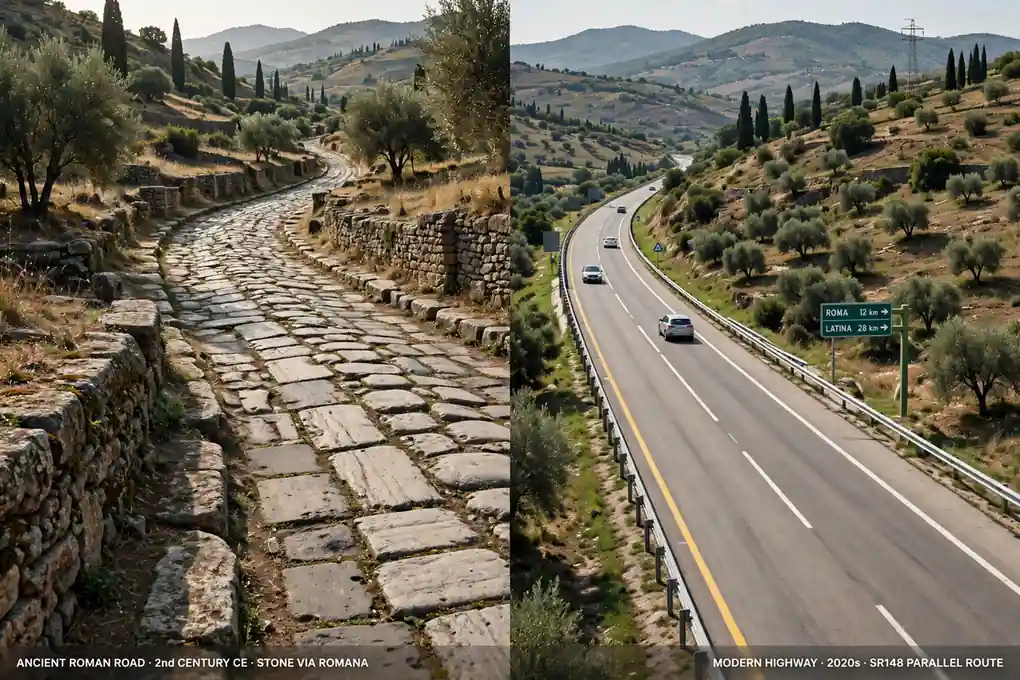
But the roads still shaped the landscape in ways that persisted. Many medieval roads followed the routes of Roman roads, even where the original pavement was long gone. And many of those medieval roads became early modern roads, and many of those became today’s roads.
The M1 motorway in England — one of Britain’s main north-south highways — follows the route of Ermine Street, the Roman road connecting London to York, for significant stretches. The A5 in England closely follows the route of Watling Street. In France, the Route Nationale 7 follows the Via Aurelia. In Italy, the Via Appia Nuova (New Appian Way) runs alongside and in many places exactly on top of the ancient original.
This continuity is extraordinary when you think about it. The Romans made route decisions nearly two thousand years ago, and those decisions still determine how millions of people commute to work today.
Ancient Roman Roads You Can Still Visit Today
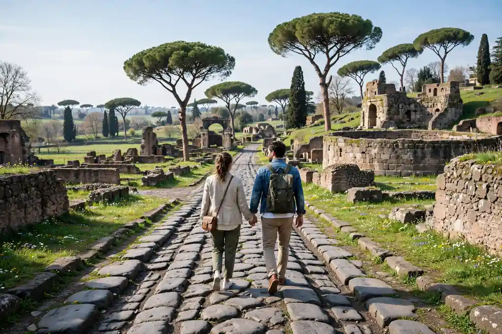
One of the genuinely wonderful things about ancient Roman roads is that they’re not just a historical abstraction. You can go and walk on them. Stand on them. Put your hand on stones that were placed by Roman workers who have been dead for two millennia.
The Via Appia Antica outside Rome is probably the most famous and most accessible. The stretch that begins at the Porta San Sebastiano and runs south through the Campagna Romana is one of the great walks in Italy. You’ll see original paving stones, ancient tombs lining the roadside (Romans buried their dead outside city walls, so the roads were often lined with tombs), and the remains of villas and aqueducts. It’s peaceful, slightly eerie, and deeply moving.
Pompeii offers another extraordinary experience. The streets of Pompeii are Roman streets, frozen in time by the eruption of Vesuvius in 79 AD. You can walk on the original basalt paving stones, see the raised stepping stones that pedestrians used to cross the street without getting their feet wet (and which were carefully spaced so that cart wheels could pass between them), and get a visceral sense of what a bustling Roman town actually felt like underfoot.
In Britain, the Fosse Way — the Roman road running diagonally from Exeter in the southwest to Lincoln in the northeast — can still be traced across the landscape and walked in sections. Much of it is now a minor road or a footpath, but the characteristic straightness and the slight raised ridge that marks the agger (the embankment on which Roman roads were built) are often clearly visible.
Hadrian’s Wall in northern England follows a Roman road for much of its length, and the Military Way running along the south side of the wall is one of the best-preserved examples of Roman road construction in Britain.
In Turkey, sections of ancient Roman roads are visible in numerous places, including along the route of the famous St. Paul Trail walking route in the southwestern part of the country.
In Jordan, the King’s Highway — which predates Rome but was incorporated into the Roman road network as the Via Traiana Nova — passes through spectacular desert landscape and connects biblical cities that the ancient world’s greatest travelers once walked between.
What Roman Roads Tell Us About Roman Society
Ancient Roman roads weren’t just a practical infrastructure project. They were an expression of Roman values and Roman ambitions in a very tangible form.
The sheer investment required to build and maintain the road network says something about how the Romans thought about the state and its responsibilities. Building a road is a commitment to the future — you’re investing enormous resources now for benefits that will accrue over decades or centuries. That kind of long-term thinking reflects a society with real institutional continuity and a genuine sense of collective identity.
The standardization of Roman road construction across wildly different environments and cultures reflects the Romans’ talent for creating systems that could be replicated. The same engineering principles that produced a road in Italy produced a road in Egypt or Scotland. This was one of Rome’s great gifts to the territories it conquered — not just specific roads, but road-building knowledge and standards.
The legal framework around Roman roads is also interesting. Major public roads were res publicae — public things, belonging to everyone — and there were detailed laws protecting them and regulating their use. Property owners alongside roads had specific obligations and specific rights. There were regulations about road widths, about the right to pass, about maintenance responsibilities. This legal infrastructure was as important as the physical infrastructure in some ways.
Roads also functioned as expressions of power and control. Building a road through new territory was a way of claiming it, organizing it, and incorporating it into the Roman world. When Roman engineers surveyed a new road route, they were doing something that was simultaneously practical and political.
And roads made the famous Roman efficiency in military deployment possible. The ability to move a legion from one end of the empire to the other with speed and predictability was a profound strategic advantage that Rome’s enemies rarely had.
Conclusion
Ancient Roman roads are, in the most literal sense, one of the foundations of the modern world. The network that Rome spent centuries building shaped the geography of human settlement, trade, and movement in ways that we’re still living with today. When you drive on a British motorway that follows a 2,000-year-old route, or walk on paving stones in Rome that were laid down before Christianity existed, you’re not just experiencing history — you’re experiencing the still-living consequences of choices made by engineers and emperors who have been gone for more than a thousand years.
What makes ancient Roman roads so compelling isn’t just their age or their extent, though both are impressive. It’s the quality of thinking that went into them. The Romans understood that a road is an investment in connectivity — in the ability of people, goods, and ideas to move from one place to another. They understood that good drainage and solid foundations were worth the extra labor. They understood that a network is worth more than any individual road because of the connections it enables.
These are lessons that remain relevant. Infrastructure built thoughtfully and maintained consistently outlasts the people and even the civilizations that built it. That’s not a bad legacy for a civilization to leave behind.
So the next time you’re walking down a surprisingly straight road in the European countryside, or you notice that a modern highway takes an inexplicably Roman-looking line across a map, spare a thought for the surveyors and soldiers and laborers who made it all possible. They built something that was meant to last — and it did.
Also Read: Best Sights In Rome That Will Stop You Mid Step And Take Your Breath Away
Frequently Asked Questions
How long did it take to build Roman roads?
It varied enormously. A short stretch of straight road on easy ground could go up in weeks if soldiers were available. Major projects like the Appian Way took years. The Appian Way’s original 132-mile section was built over roughly two years, which was extremely fast for the scale. Larger networks developed over decades and centuries, with road systems extended, improved and rerouted as the empire grew.
Why were Roman roads so straight?
Several reasons: first, military efficiency. The shortest distance between two points is a straight line, and military commanders wanted to reach destinations as quickly as possible. Second, Roman engineers preferred straight routes for surveying accuracy. Third, straight roads were easier to defend and control. Where the terrain allowed it, engineers drew straight lines across the landscape. In hilly or mountainous areas, roads had to curve, but the ideal was always the direct route.
What materials were Roman roads made from?
The typical road used several distinct layers. The foundation was large stones (statumen), followed by smaller stones and gravel (rudus), then finer material (nucleus), and topped with fitted stone paving blocks (summa crusta or summum dorsum). In some areas, roads were surfaced with basalt blocks, particularly in Italy. In other areas, gravel and local materials were used when good stone was not available.
How did the Romans survey such long straight roads?
Roman surveyors used the groma, a cross-shaped instrument with plumb lines that allowed them to sight straight lines over long distances. They used the chorobates, a long trough filled with water, for levelling. They also used mathematical principles that they refined over centuries. Roads were planned with straight sections between visible landmarks, and because their survey methods were accurate, many Roman roads ran in straighter lines than roads built centuries later.
Are any Roman roads still used today?
Yes, in various ways. Many modern roads follow the routes established by Roman roads. The A5 in England follows Watling Street, the M1 follows Ermine Street, and parts of France’s Route Nationale 7 trace the Via Aurelia. Many sections of Roman roads are still walked, cycled or driven on, and some segments still carry traffic on their original stone surface, though most modern traffic requires adapted surfaces.
What was the longest Roman road?
In total, the Romans built about 50,000 miles (80,000 km) of hard-surfaced highway across the empire. The longest single road was the Via Egnatia at around 700 miles (1,120 km). The Appian Way was about 350 miles (563 km) in its full form. Source: Britannica’s Roman road system overview.
How fast could people travel on Roman roads?
Official couriers using horse relays could cover up to 50 miles (80 km) per day. Ordinary travellers on foot typically managed 20 to 30 miles per day. Wagons moved more slowly, typically 10 to 15 miles per day. Military legions on a forced march might cover 30 miles in five hours. The combination of high-quality surfaces and regular rest stations allowed consistent speeds that remained unusual until the modern era.
Did Roman roads have traffic rules?
Yes, and they were quite sophisticated. The city of Rome had restrictions on wheeled traffic during the day, requiring carts to move at night. Roman law gave right of way to certain vehicles, and specific routes were reserved for military use. Roads included rules about maintenance responsibilities, and there were penalties for damaging road surfaces. Milestones and signs indicated directions and distances from Rome.
Why did Roman roads outlast most other ancient infrastructure?
Because they were built using the same engineering principles that we now use for modern roads: proper foundations, drainage, and the use of durable materials. The multi-layer construction provided strength and stability. The Romans also built for the long term, accepting higher upfront costs for infrastructure that would serve the empire for centuries. Today, the remnants of these roads still impress engineers.
How did Roman roads influence modern road construction?
Roman road engineering principles became the foundation of modern road building. Engineers still use the same basic layering systems. The Romans understood drainage, foundations, and the need for straight, well-engineered routes. In European law, some Roman road rights are still in effect today, and many modern highways in Europe follow ancient Roman routes.